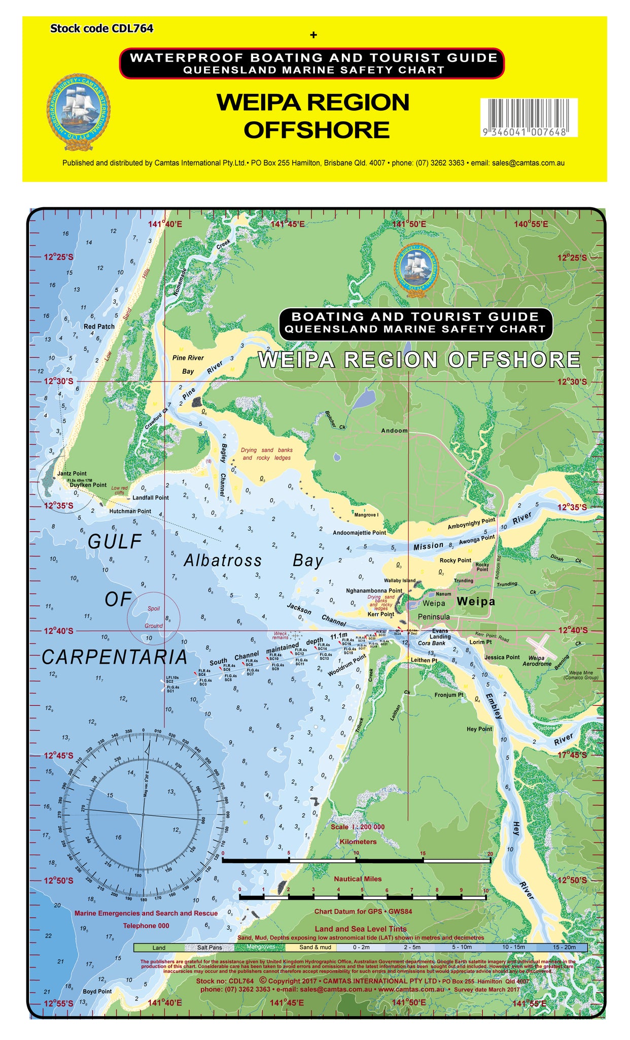
WEIPA REGION OFFSHORE
Queensland Boating, Fishing, Sea Search and Rescue Guide laminated chart - Size 22 x 31 cm - CAMTAS
Side 1: Camtas Boating Guide, Marine Safety Chart. Side 2: Queensland Marine Safety Smooth, Partially Smooth and Open Waters
Features
-
Water contours are shades of blue becoming progressively darker as depth increases
-
Land contours become progressively darker as height increases
-
Natural features, mangroves, sand types, mud, salt pans and others features are visually realistically depicted
-
Grid reference system simplifies identifying positions for boating, fishing and rescue services
-
Marine Emergency Search and Rescue contact details for Police and Volunteer Rescue Services phone number is located on the chart
-
Navigation symbols are clearly explained on the chart without the need for supplementary handbook
-
Known information such as names, heights, depths, seabed, GPS marks, obstructions and navigational tracks included
-
No fishing Zones, officially declared speed zones clearly indicated
-
Lesser known information such as local knowledge of fishing and diving locations, local common names and information from latest satellite images are included at time of publication
Camtas Background
Camtas management has a wealth of practical knowledge, spanning over 65 years of combined personal experiences, naval, yachting, amateur and professional fishing, deep sea and reef scuba diving, underwater photography, ichthyology, marine aquariums, marine rescue and cartography.
Camtas Marine Safety Chart was first published in year 1973 for a local Marine Search & Rescue Group who sought help to create a user friendly grid type search and rescue chart for their local area. New publications have followed due its instant success and numerous requests from similar groups and public.
Side 1 contains easily identified places of interest:
GULF OF CARPENTARIA, Albatross Bay, Red Patch, Pine River Bay, Nomemade Creek, Pine River, Crawford Ck, Botcher Ck, Jantz Point, Duyfken Point, Landfall Point, Hutchman Point, Bagley Channel, Andoom, Mangrove Is, Andoomajettie Point, Amboynighy Point, Awonga Point, Rocky Point, Mission River, Jackson Channel, South Channel, Wallaby Island, Weipa Peninsula, Trunding Ck, Trunding, Nanum, Weipa, Evans Landing, Dinah Ck, Cora Bank, Nghanambonna Point, Kerr Point, Wooldrum Point, Kerr Point, Weipa Aerodrome, Weipa Mine, Beening Ck, Lorim Pt, Jessica Point, Leithen Pt, Triluck Creek, Leithan Ck, Fronjum Pt, Hey Point, Embley River, Hey River, Boyd Point
Side 2: Queensland Marine Safety Smooth, Partially Smooth and Open Waters;
- Smooth waters include rivers, streams and lakes, waters within breakwaters or revetments and within half a nautical mile from land within partially smooth limits and other waters specified in legislation.
- Partially smooth waters are determined by MSQ as specified in legislation.
- Beyond are waters seaward from the smooth waters or partially smooth waters.
- The red line designates the 2nM limit which EPIRBs must be carried. EPIRB required when operating beyond partially smooth waters and more than 2 nautical miles from land, that is, a part of the earth’s surface (other than a reef) above the high water mark at spring tides.