


QLD Boating, Fishing, Camtas Marine Safety Chart - HINCHINBROOK CHANNEL, Hinchinbrook Island / MC690
Regular price
$31.35
Sale
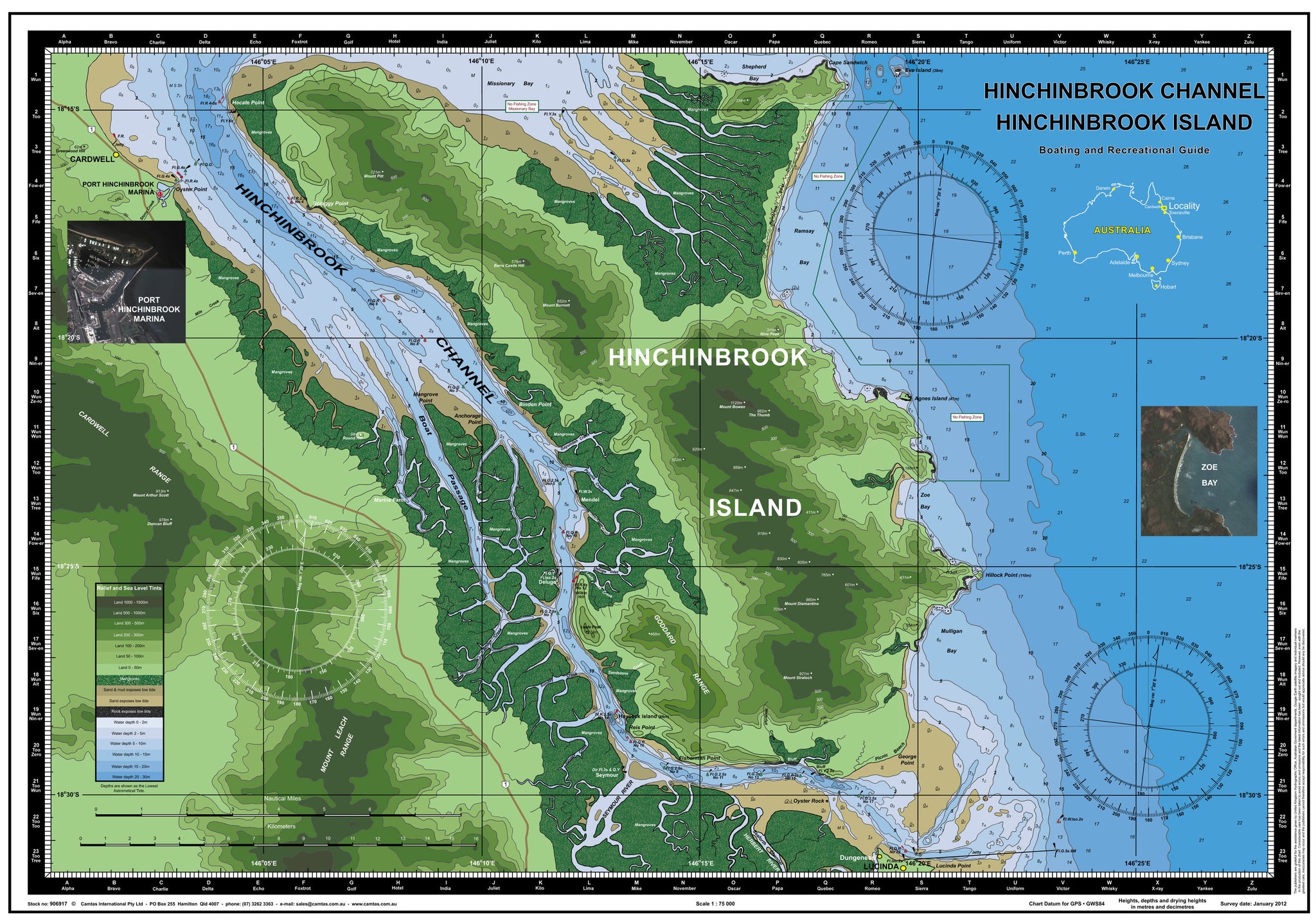
HINCHINBROOK CHANNEL, HINCHINBROOK ISLAND
Boating, Fishing, Marine Safety Chart - Camtas publication MC690
BONUS wall chart - Fish of Australia, Anglers Guide reverse side
Size 48.5 x 70 cm
Features
- Water contours are shades of blue becoming progressively darker as depth increases
- Land contours become progressively darker as height increases
- Natural features, reefs,mangroves, sand types, mud, salt pans and others features are visually realistically depicted
- Grid reference system simplifies identifying positions for boating, fishing and rescue services
- Marine Emergency Search and Rescue contact details for Police and Volunteer Rescue Services phone numbers including radio frequencies monitored are easily located on the chart
- Navigation symbols are clearly explained on the chart without the need for supplementary handbook
- Known information such as names, heights, depths, seabed, GPS marks, obstructions and navigational tracks included
- Satellite positions derived from the WGS1984 datum can be plotted directly onto this chart
- No fishing Zones, officially declared Smooth, Partially smooth, Open waters zones clearly indicated
- Lesser known information such as local knowledge of fishing and diving locations, local common names and information from latest satellite images are included at time of publication
- An affordable chart and perfect gift or reference guide both at home or on holidays
Marine chart contains easily identified places of interest:
HINCHINBROOK ISLAND Hecate Point Mount Pitt Scraggy Point Greenwood Hill CARDWELL PORT HINCHINBROOK MARINA Stony Creek Oyster Point Mile Creek Barra Castle Hill Mount Burnett Nine Peak Eve Island Cape Sandwich CARDWELL RANGE Mount Arthur Scott Duncan Bluff Round Hill Conn Creek Mangrove Point Anchorage Point Mount Bowen The Thumb Binden Point Gayundah Creek Paluma Creek Mendel Mendel Creek Deluge Inlet Leefe Peak Creek Agnes Island Hillock Point Mount Diamantina Deluge Wilkin Hill Leefe Peak GODDARD RANGE Bridge Creek Sunday Creek Sandstone Creek Mount Straloch Haycock island MOUNT LEACH RANGE Sunday Creek Fisherman Point Seymour Reis Point SEYMOUR RIVER Waterfall Creek Oyster Rock Picnic Beach George Point Dungeness LUCINDA Lucinda Point HINCHINBROOK CHANNEL
BONUS wall chart - Fish of Australia, Anglers Guide reverse side
Browse over high quality Illustrations and learn names, average and growth sizes, habitat, places where found, flesh description and eating qualities
Species included: Sailfish, Black Marlin, Blue Marlin, Striped Marlin, Big Eye Tuna, Mahi Mahi, Wahoo, Spanish Mackerel, Spotted Mackerel, Grey Mackerel, School Mackerel, Cobia Longtail Tuna Mackerel, Tuna, Amberjack, Samson Fish, Yellowtail Kingfish, Tailor, Silver Trevally, Australian Bonito, Great Barracuda, Barramundi, Giant Queenfish, Golden Trevally, Mulloway, Turrum, Striped Barracuda, Rainbow Runner, Snapper, Saddletail Snapper, Rosy Snapper, Teraglin, Red Emperor, Barramundi Cod, Coral Rockcod, Bluespotted Coral Trout, Chinese Footballer Coral Trout Barcheek Coral Trout, Coronation Trout, Common Coral Trout, Redthroat Emperor, Pearl Perch, Birdwire Rockcod, Queensland Groper, Venus Tuskfish, West Australian Dhufish, Bluebarred Parrotfish, Hussar, Maori Wrasse, Maori Rockcod, Moses Snapper, Australian Salmon, Grey Morwong, Silver Sweep Eastern Blue Groper, Rock Blackfish, Stripey Snapper, Red Morwong, Painted Sweetlips, Golden Snapper, Estuary Rockcod, Grass Emperor, Tripletail, Leatherjacket, Mangrove Jack, John Dory, Gold Spot Wrasse, Spangled Emperor, Goatfish, Swallowtail Dart, King George Whiting, Garfish, Trumpeter Whiting, Sand Whiting, Sergeant Baker, Yellowfin Bream, Black Rabbitfish, Diamondfish, Luderick, Sea Mullet, Eastern Scorpionfish, Striped Scat, Black Bream, Barred Javelinfish, King Threadfin, Sand Flathead, Pinkbanded Grubfish, Blue Catfish, Tarwhine, Black Jewfish, Blue Theadfin, Silver Javelinfish, Australian Bass, Chinamanfish, Red Bass, Paddletail, Bony Bream, Sleepy Cod, Carp, Goldfish, Silver Perch, Golden Perch, Saratoga, Freshwater Catfish, Macquarie Perch, Murray Cod, Tench, Brown Trout, Brook Trout, Rainbow Trout, Sooty Grunter, Redfin
Size 48.5 x 70 cm
-
Available in 2 variants
-
LAMINATED both sides with premium grade 80 um plastic film to ensure product has long life, permanently WATERPROOF and resilient to damage.
Marine chart side has non- reflective matte finish laminate specially formulated in manufacture of surface to allow navigators the benefit of being able to DRAW ON THE SURFACE WITH PENCIL OR INK. Pencil and most inks easily removed with eraser, permanent ink with mentholated spirit.
- Premium 170gsm paper folded into A4 size plastic wallet
-
Camtas Background
Managing Director Max E Mason has over 65 years of combined personal experiences, naval, yachting, amateur and professional fishing, deep sea and reef scuba diving, underwater photography, ichthyology, marine aquariums, marine rescue and cartography.
Marine Safety Charts were first published in year 1973 for local Marine Search & Rescue Groups who sought help to create a user-friendly grid type search and rescue chart for their local area. New publications have followed due its instant success and numerous requests from similar groups and public.