


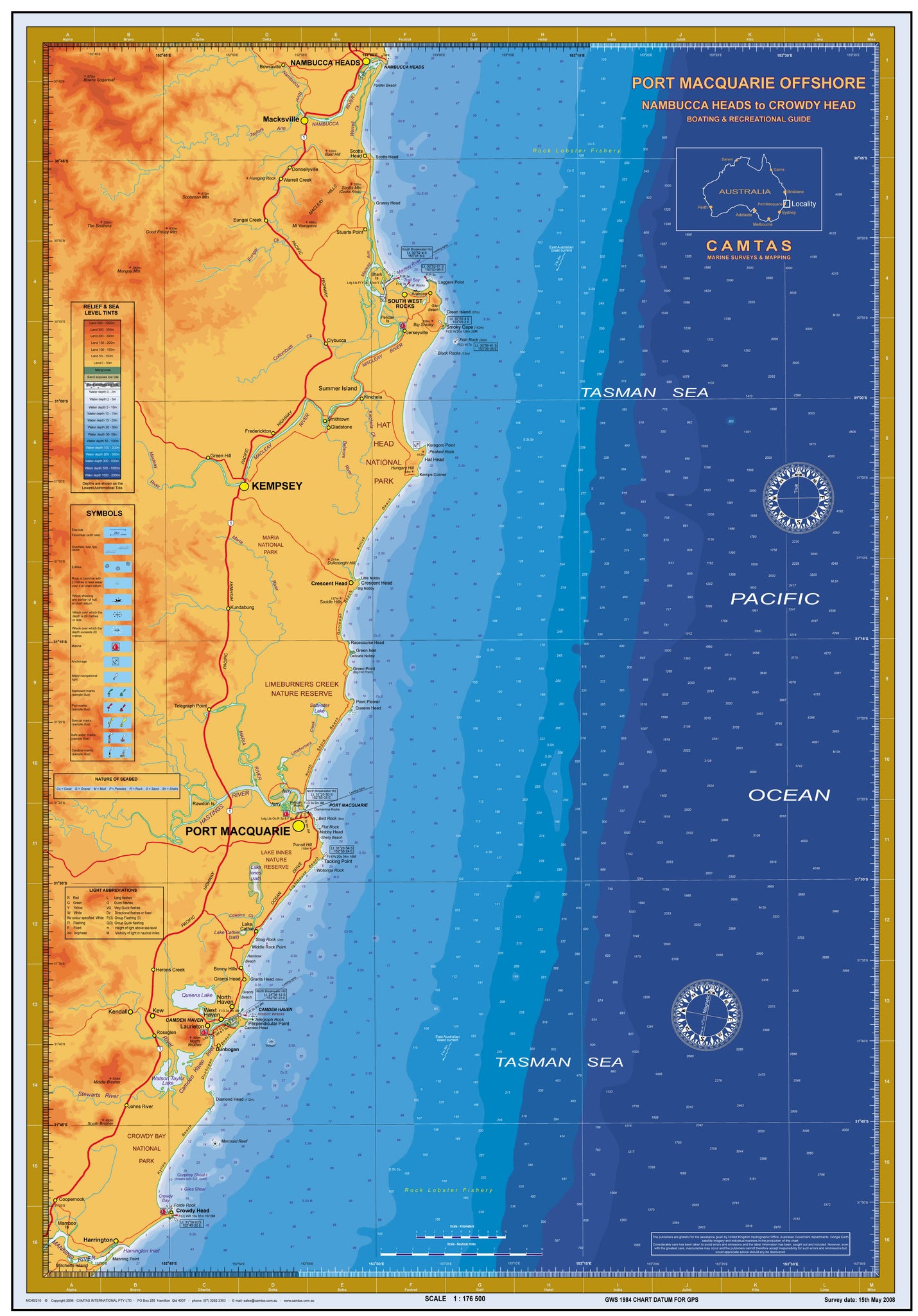


NSW Boating, Fishing, Marine Safety Chart - CROWDY HEAD to NAMBUCCA HEAD, Pt Macquarie + BONUS / MC450
Regular price
$41.25
Sale
CROWDY HEAD to NAMBUCCA HEAD
SOUTH WEST ROCKS, CRESCENT HEAD, PORT MACQUARIE, CAMDEN HAVEN, HARRINGTON
Boating, Fishing, Marine Safety Chart - Camtas publication MC450
BONUS wall chart - Fish of Australia, Anglers Guide reverse side
Size 61 x 88 cm
Features
- Water contours are shades of blue becoming progressively darker as depth increases
- Land contours become progressively darker as height increases
- Natural features, reefs,mangroves, sand types, mud, salt pans and others features are visually realistically depicted
- Grid reference system simplifies identifying positions for boating, fishing and rescue services
- Marine Emergency Search and Rescue contact details for Police and Volunteer Rescue Services phone numbers including radio frequencies monitored are easily located on the chart
- Navigation symbols are clearly explained on the chart without the need for supplementary handbook
- Known information such as names, heights, depths, seabed, GPS marks, obstructions and navigational tracks included
- Satellite positions derived from the WGS1984 datum can be plotted directly onto this chart
- No fishing Zones, officially declared Smooth, Partially smooth, Open waters zones clearly indicated
- Lesser known information such as local knowledge of fishing and diving locations, local common names and information from latest satellite images are included at time of publication
- An affordable chart and perfect gift or reference guide both at home or on holidays
Camtas Background
Camtas management has a wealth of practical knowledge, spanning over 65 years of combined personal experiences, naval, yachting, amateur and professional fishing, deep sea and reef scuba diving, underwater photography, ichthyology, marine aquariums, marine rescue and cartography.
Camtas Marine Safety Chart was first published in year 1973 for a local Marine Search & Rescue Group who sought help to create a user friendly grid type search and rescue chart for their local area. New publications have followed due its instant success and numerous requests from similar groups and public.
Places of interest from Crowdy Head to Nambucca Head
NAMBUCCA HEADS Bowraville Nambucca River Forster Beach Scotts Head Grassy Head Arakoon Macleay Arm Green Island Gap Beach Smoky Cape Trail Bay Laggers Point Fish Rock Black Rocks Macksville Taylors Arm Warrell Ck Scotts Head Donnellyville Eungai Creek Stuarts Point Eungai Ck Shark Is SOUTH WEST ROCKS Pelican Is Collombatti Ck Clybucca Jerseyville MACLEAY RIVER Summer Island Kinchela Smithtown Gladstone Belmore River TASMAN SEA KEMPSEY Crescent Head Maria River Kundabung Peaked Rock Hat Head Kemps Corner Killick Beach Little Nobby Big Nobby Goolawah Beach Racecourse Head Green Islet Delicate Nobby Green Point Point Plomer Queens Head North Shore Beach Diamantina Rocks Bird Rock Flat Rock Nobby Head Shelly Beach PACIFIC OCEAN Limeburners Creek Telegraph Point HASTINGS RIVER PORT MACQUARIE Rawdon Is Cowarra Ck Lake Cathie Herons Creek Bonny Hills Tacking Point Wotonga Rock Lighthouse Beach Lake Innes Shag Rock Middle Rock Point Rainbow Beach Grants Head Grants Beach Dunbogan Beach Telegraph Rock Perpendicular Point Camden Head Diamond Head Mermaid Reef Curphey Shoal Mermaid Reef Giles Shoal Kylies Beach Crowdy Bay Grants Head Queens Lake North Haven West Haven CAMDEN HAVEN Laurieton Dunbogan WatsonTaylor Lake Camden Haven Inlet Stewarts River Johns River CROWDY BAY NATIONAL PARK Coopernook Mamboo Is Mitchells Island MANNING RIVER Harrington Forde Rock Hamington Inlet Manning Point Crowdy Head
BONUS wall chart Fish of Australia, Anglers Guide Poster
Browse over high quality Illustrations and learn names, average and growth sizes, habitat, places where found, flesh description and eating qualities.
Species included: Sailfish, Black Marlin, Blue Marlin, Striped Marlin, Big Eye Tuna, Mahi Mahi, Wahoo, Spanish Mackerel, Spotted Mackerel, Grey Mackerel, School Mackerel, Cobia Longtail Tuna Mackerel, Tuna, Amberjack, Samson Fish, Yellowtail Kingfish, Tailor, Silver Trevally, Australian Bonito, Great Barracuda, Barramundi, Giant Queenfish, Golden Trevally, Mulloway, Turrum, Striped Barracuda, Rainbow Runner, Snapper, Saddletail Snapper, Rosy Snapper, Teraglin, Red Emperor, Barramundi Cod, Coral Rockcod, Bluespotted Coral Trout, Chinese Footballer Coral Trout Barcheek Coral Trout, Coronation Trout, Common Coral Trout, Redthroat Emperor, Pearl Perch, Birdwire Rockcod, Queensland Groper, Venus Tuskfish, West Australian Dhufish, Bluebarred Parrotfish, Hussar, Maori Wrasse, Maori Rockcod, Moses Snapper, Australian Salmon, Grey Morwong, Silver Sweep Eastern Blue Groper, Rock Blackfish, Stripey Snapper, Red Morwong, Painted Sweetlips, Golden Snapper, Estuary Rockcod, Grass Emperor, Tripletail, Leatherjacket, Mangrove Jack, John Dory, Gold Spot Wrasse, Spangled Emperor, Goatfish, Swallowtail Dart, King George Whiting, Garfish, Trumpeter Whiting, Sand Whiting, Sargeant Baker, Yellowfin Bream, Black Rabbitfish, Diamondfish, Luderick, Sea Mullet, Eastern Scorpionfish, Striped Scat, Black Bream, Barred Javelinfish, King Threadfin, Sand Flathead, Pinkbanded Grubfish, Blue Catfish, Tarwhine, Black Jewfish, Blue Theadfin, Silver Javelinfish, Australian Bass, Chinamanfish, Red Bass, Paddletail, Bony Bream, Sleepy Cod, Carp, Goldfish, Silver Perch, Golden Perch, Saratoga, Freshwater Catfish, Macquarie Perch, Murray Cod, Tench, Brown Trout, Brook Trout, Rainbow Trout, Sooty Grunter, Redfin
Size 61 x 88 cm
-
Available in 2 variants
-
LAMINATED both sides with premium grade 80 um plastic film to ensure product has long life, permanently WATERPROOF and resilient to damage.
Marine chart side has non- reflective matte finish laminate specially formulated in manufacture of surface to allow navigators the benefit of being able to DRAW ON THE SURFACE WITH PENCIL OR INK. Pencil and most inks easily removed with eraser, permanent ink with mentholated spirit.
- Premium 170gsm paper folded into A4 size plastic wallet
-