


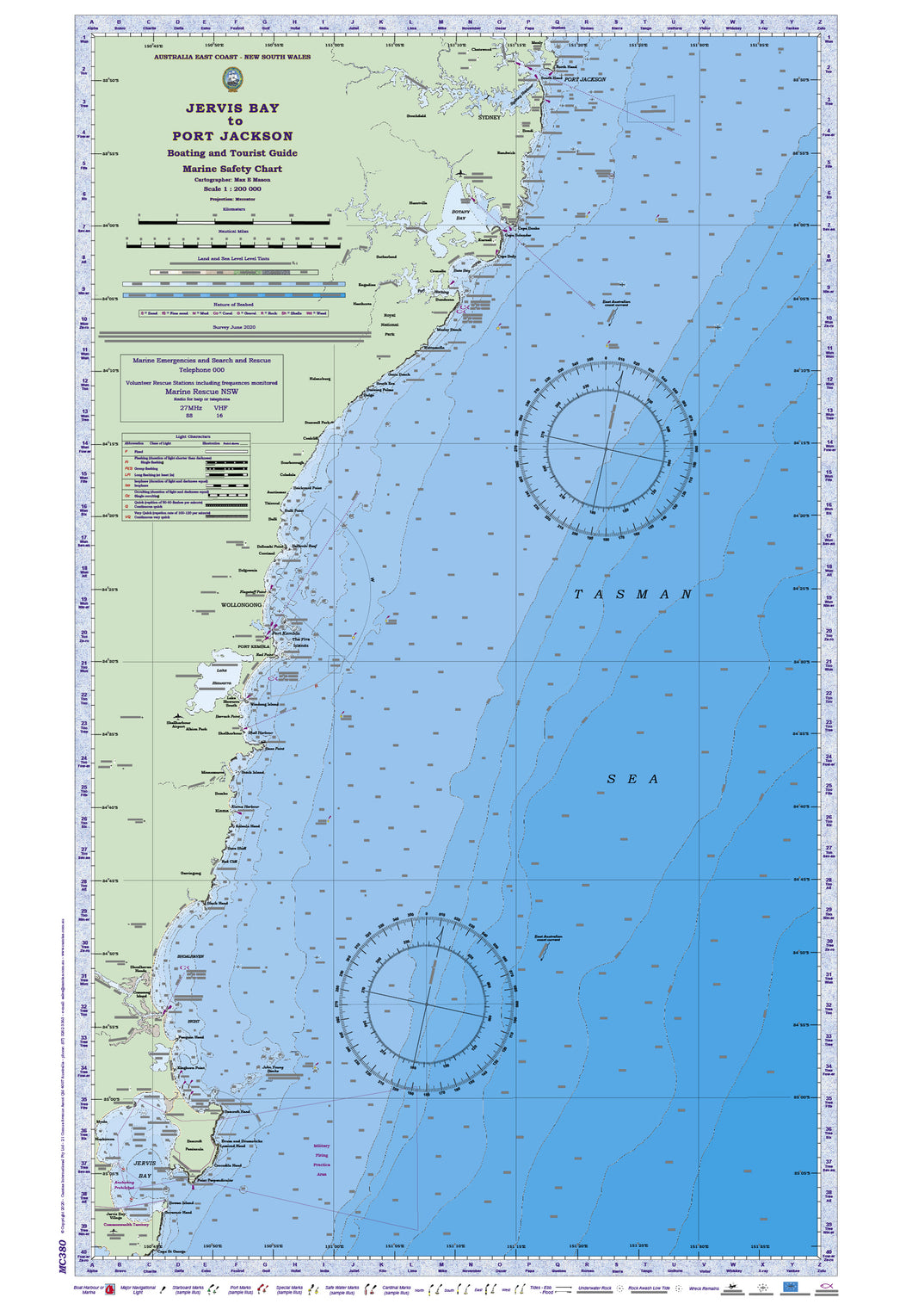


NSW Boating, Fishing, Marine Safety Chart - JERVIS BAY to PORT JACKSON + BONUS / MC380
Regular price
$41.25
Sale
JERVIS BAY to PORT JACKSON
Boating, Fishing, Marine Safety Chart - Camtas publication MC380
BONUS WALL CHART - New South Wales Fishers Guide to species identification, legal size and limits - reverse side
Size 61 x 88 cm
Features
- Water contours are shades of blue becoming progressively darker as depth increases
- Land contours become progressively darker as height increases
- Natural features, reefs, mangroves, sand types, mud, salt pans and others features are visually realistically depicted
- Grid reference system simplifies identifying positions for boating, fishing and rescue services
- Marine Emergency Search and Rescue contact details for Police and Volunteer Rescue Services phone numbers including radio frequencies monitored are easily located on the chart
- Navigation symbols are clearly explained on the chart without the need for supplementary handbook
- Known information such as names, heights, depths, seabed, GPS marks, obstructions and navigational tracks included
- Satellite positions derived from the WGS1984 datum can be plotted directly onto this chart
- No fishing Zones, officially declared Smooth, Partially smooth, Open waters zones clearly indicated
- Lesser known information such as local knowledge of fishing and diving locations, local common names and information from latest satellite images are included at time of publication
- An affordable chart and perfect gift or reference guide both at home or on holidays
Places of interest:
JERVIS BAY, Jervis Bay Village, HMAS Creswell, Jervis Bay Airport, Cape St George, Commonwealth Territory, Governor Head, Darling Road, Captains Point, Bowen Island, Middle Ground, Point Perpendicular, Bombora Rock, Longnose Point, Plantation Point, Crocodile Head, Lamond Head, Beecroft Peninsula, Drum and Drumsticks, Montagu Roadstead, Military Firing Practice Area, Huskisson, Dent Rock, Myola, Montagu Point, Green Point, Currarong, Beecroft Head, Little Beecroft Head, Crookhaven Bight, Callala Point, Hare Bay John Young Banks Warrain Beach Red Point Kinghorn Point Penguin Head Wollumboola Lake, Crookhaven River, Greenwell Point, Comerong Island, Shoalhaven River, SHOALHAVEN BIGHT Artificial Reef 34o50.955’ S 150o47.731’ E Shoalhaven Heads Coolangatta Mt, Moeyan Hill, Seven Mile Beach, Black Rock, Black Head, Gerringong, Gearing Bay, Werri Beach Red Cliff Bare Bluff Kaleula Head Saddleback Kiama Kiama Harbour Bombo Minnamurra River Minnamurra Stack Island Bass Point Shell Harbour Shellharbour Albion Park Knights Hill Shellharbour Airport Mount Johnston Barrack Point Windang Island Lake Illawarra South TASMAN SEA Wollingurry Point Tallawarra Point Lake Illawarra Kanahooka Point Perkins Beach Red Point PORT KEMBLA Flagstaff Hill Port Kembla Tom Thumb Islands The Five Islands Big Island Martin Island Artificial Reef 34o31.037’ S 150o54.908’ E Mount Kembla Mount Nebo Mount Kiera Flagstaff Point WOLLONGONG Balgownie Corrimal Brokers Nose Bellambi Point Bellambi Reef Bulli Bulli Point Thirroul Austinmer Brickyard Point Coledale Scarborough Coalcliff Stanwell Park Bulgo Helensburg Burning Palms South Era Garie Beach Middle Hill Wattamolla Royal National Park Marley Beach Artificial Reef 34o05.936’ S 151o10.438’ E Jibbon Hill Heathcote Engadine Hacking River Bundeena Port Hacking Jibbon Bumbora Artificial Reef 34o05.660’ S 151o10.668’ E Osborn Shoal Cronulla Bate Bay Cronulla Beach Cape Baily Sutherland Woronora River Kurnell Cape Solander Georges River BOTANY BAY Hurstville Cape Banks Long Bay Maroubra Bay Sydney (Kingsford-Smith) Airport Randwick Coogee Bay Bondi Ben Buckler Strathfield SYDNEY Parramatta River Chatswood Middle Harbour Manly Manly Rock Blue Fish Point North Head South Head Sydney Harbour PORT JACKSON
BONUS: Fishers Guide to fish species of New South Wales region identifies 222 beautifully illustrated fresh and salt water species: fish, crustaceans and more.
Browse over images and learn names, bag limits, legal sizes, habitat and eating qualities and more.
Species include: Estuary Perch, Silver Perch, Atlantic Salmon, Brook Trout, Longfin Eel, Australian Bass, Golden Perch, Brown Trout, Freshwater Catfish, European Carp, Southern Shortfin Eel, Redfin, Macquarie Perch, Rainbow Trout, Murray Cod, Trout Cod, Bullrout, Goldfish, Tench, Diamondfish, Common Silverbiddy, Longfin Pike, Banded Goatfish, Milkfish, Sailfish, Blue Marlin, Pacific Bonefish, Sergeant Baker, Striped Barracuda, Spangled Perch, Purple Rockcod, Amberjack, Striped Marlin, Spotted Stargazer, Stout Longtom, Jack Mackerel, Painted Grinner, Yellowstripe Leatherjacket, Velvet Leatherjacket , Eastern Red Scorpionfish, Mulloway, Samsonfish, Tomato Rockcod, Mirror Dory, Mosaic Leatherjacket, Silver Dory, Black Marlin, Maori Rockcod, Blacktip Rockcod, Chinaman Rockcod, Swordfish, Spearfish, John Dory, Sixspine Leatherjacket, Longtail Tuna, Bigeye Tuna, Southern Bluefin Tuna, Albacore, Yellowfin Tuna , False Fusilier, Blue Morwong, Bass Groper, Doubleline Fusilier, Spangled Emperor, Murray Crayfish, Eastern Freshwater Crayfish, Freshwater Crayfish (Yabby, Trumpeter Whiting, Banded Rockcod, Red Morwong, Blue-eye Trevalla, Sand Whiting, Blue Weed (Grass) Whiting, Bluespotted Flathead, Stout Whiting, King George Whiting, School Whiting, Tiger Flathead, Bartail Flathead, Southern Sand Flathead, Striped Catfish, Longspine Flathead, Yellowfin Bream, Luderick, Black Bream, Snapper, Estuary Cobbler, Australian Bass, Estuary Perch, Tarwhine, Goldspot Pigfish, Crested Morwong, Blue-barred Parrotfish, Grey Morwong (Rubberlip Morwong), Redfish, Stripey Snapper, Moses Snapper, Reef Ocean Perch, Pearl Perch, Tropical Rocklobster, Eastern Rocklobster, Banded Morwong, Black Stingray, Venus Tuskfish, Jackass Morwong, Slipper Lobster, Bastard Trumpeter, Striped Trumpeter, Purple Tuskfish, Southern Rocklobster, Mako Shark, Gemfish, School Shark, Tiger Shark, Blue Shark, Hapuku, Snubnose Dart, Longfin Perch, Bluestriped Snapper, Hussar, Goldband Snapper, Ruby Snapper, Silver Trevally, Tailor, Swallowtail Dart, Blackspot Snapper, Fiveline Snapper, Golden Trevally, Mangrove Jack, Diamond Trevally, Smallspotted Dart, Giant Trevally, Sea Mullet, Sole, Australian Salmon, Hairtail, Rock Blackfish, Spotted Bigeye, Eastern Sea Garfish, Giant Boarfish, Barracouta, Rock Ling, Flame Snapper, Green Jobfish, Red Gurnard, Comb Wrasse, Rosy Snapper, Eastern King Wrasse, Teraglin, Soldier Crab, Cockles, Abalone, Sydney Rock Oyster, Blue Swimmer Crab, Sea Urchin, Saltwater Nippers, Pipi, Cunjevoi, Commercial Scallop, Balmain Bug, Mud (Black/Mangrove) Crab, Periwinkle, Squid, Blue Mussels, Cuttlefish, Roundface Batfish, Old Wife, Tallfin Flyingfish, Spanish Mackerel, Spotted Mackerel, Rainbow Runner, Australian Bonito, Frigate Mackerel, Blue Drummer, Elegant Wrasse, School Mackerel, Mahi Mahi, Blue Groper (Red, Brown Groper), Crimsonband Wrasse, Ballina Angelfish, Black Cod, Southern Bluefin Tuna, Eastern Blue Devilfish, Goldspotted (Estuary) Rockcod, Green Sawfish, Herbsts Nurse Shark, Wirrah, Red Emperor, Grey Nurse Shark, Comet Grouper, Highfin Grouper, Banded Wobbegong, Queensland Groper, Great White Shark, Brassy Drummer, Silver Drummer, Bluefish, Black Rabbitfish (Happy Moments), Starry Triggerfish, Striped Scat, Australian Sawtail, Stripey, Fourline Striped Grunter, Silver Sweep, Bluespine Unicornfish, Sea Sweep
Size 61x88cm
-
Available in 2 variants
-
LAMINATED both sides with premium grade 80 um plastic film to ensure product has long life, permanently WATERPROOF and resilient to damage.
Marine chart side has non- reflective matte finish laminate specially formulated in manufacture of surface to allow navigators the benefit of being able to DRAW ON THE SURFACE WITH PENCIL OR INK. Pencil and most inks easily removed with eraser, permanent ink with mentholated spirit.
- Premium 170gsm paper folded into A4 size plastic wallet
-
Camtas Background
Camtas management has a wealth of practical knowledge, spanning over 65 years of combined personal experiences, naval, yachting, amateur and professional fishing, deep sea and reef scuba diving, underwater photography, ichthyology, marine aquariums, marine rescue and cartography.
Camtas Marine Safety Chart was first published in year 1973 for a local Marine Search & Rescue Group who sought help to create a user friendly grid type search and rescue chart for their local area. New publications have followed due its instant success and numerous requests from similar groups and public.